
MAP AND DATABASE OF POSTGLACIAL PALAEOENVIRONMENTAL RECORDS IN THE PRAIRIE PROVINCES
Information about these palaeoenvironmental sites, plus others from adjacent British Columbia, Yukon, Northwest Territories and a few from the northern US, have been assembled into a database. This database builds on a previous compendium for Alberta compiled by Beaudoin (1993).
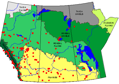
In total, the database includes information about 187 sites. For each site, the information provided includes the latitude and longitude, the site name, a basal radiocarbon date and the material dated (if available), and at least one accessible citation for a discussion of the site and source of the data. An example of one database entry is shown below:
57.46.00 -112.06.00; Eaglenest Lake
Data type: Pollen
Date: Beta-8287 10740 +/- 150 Mat.: Org. mat. (treated to remove bitumen)
Vance, R.E., 1986. Pollen Stratigraphy of Eaglenest Lake, Northeastern
Alberta. Canadian Journal of Earth Sciences 23: 11-20.
This database is freely available as a MapPad datafile. This is a straightforward text file that may be downloaded and read by any word-processor.
References
Beaudoin, A. B., 1993. A Compendium and Evaluation of Postglacial Pollen Records in Alberta. Canadian Journal of Archaeology 17:92-112.
Ecological Stratification Working Group. 1995. A National Ecological Framework for Canada. Agriculture and Agri-Food Canada, Research Branch, Centre for Land and Biological Resources Branch and Environment Canada, State of the Environment Directorate, Ecozone Analysis Branch, Ottawa/Hull. Report and map at 1:7,500,000 scale.
Document assembled by A. B. Beaudoin. The paper was written in 1997 and reflects the state of knowledge at that time. Latest update: April 10 2011